

The case of 2019 Mississippi Floods
The 2019 Mississippi Floods were one of the major floods occurring in the Mississippi basin of the last decades. The floods were preceded by the wettest meteorological winter (December 2018 – February 2019) in the conterminous US during the 1895-2019 period of record. Consequently, high levels of soil saturation were reached, reducing the infiltration capacity of the soil. Above-than-average rainfall persisted during spring, being registered the fifth wettest meteorological spring (March 2019 – May 2019) in the conterminous US during the mentioned period of record. The heavy rainfall combined with a sudden increase in temperatures during mid-March that provoked significant snowmelt led to large runoff, resulting in extremely high water levels and floods in many parts of the Mississippi River and its tributaries. This event significantly hindered the inland waterway transport sector.
What is the impact of climate change?
Climate change effects have been noticed in Mississippi Basin since the 1970s (1). On one hand, storms are becoming more frequent and bringing more rain and snow. It is estimated that the annual precipitation has increased by 20% in the last 50 years. On the other hand, average temperatures are slowly rising, resulting in larger amounts of snowmelt and consequent runoff. These two phenomena are the sources of the larger surface runoff amounts that end in the main rivers of the Mississippi Basin, contributing to more frequent high river levels.
Furthermore, recent research has determined that a 2 degree anthropogenic global warming is expected to increase the severity of tropical cyclones in the North Atlantic basin (2). This phenomenon can contribute to the increase of compound high level risk in the lower Mississippi since the end of the wet season (March-July) coincides partially with the hurricane season (June-November). If an extremelly wet season in the Mississippi basin coincides with the occurrence of an extreme storm surge hitting the Mississippi delta, the consequences in the region could be unprecedented.
From a global perspective, the impact of climate change on inland waterways worldwide is very variable. In some waterways, extreme river level events (both floods and droughts) are already becoming more severe and frequent, such as in the Mekong River (3). In other main waterways, such as the Rhine and the Danube basins, research has shown that climate change is going to affect the river levels specially in a longer term (4). The water levels are expected to increase during the hydrological winters (November to April) due to a rise in precipitation amounts and early melting of snow, while in the hydrological summer (May to October) lower precipitation and reduced flow may trigger longer and more severe droughts. Long-lasting river droughts have already significantly impacted the inland waterway sector in recent years, such as the 2018 Rhine drought that hindered navigation from August to December that year.
What are the economic impacts?
The 2019 Mississippi Floods affected 19 states and caused more than $20 billion in losses, most of them were related to the farming, manufacturing and inland waterway freight transport sectors. The freight transport sector is particularly hit during extremely high river levels due to the navigation hindrance or halt caused by high river flow velocities and strong eddies (5). if the vessel is already in the river, freight companies may face additional expenses due to the need to hire tugboats to keep the vessels on berth, the extra-berthing time costs and the standby time of the pilots. If the vessel is waiting at the river mouth, the freight companies might face fees for the waiting time of the vessels at the anchorage. Further costs arise in case of long waiting times, since the vessels might be forced to leave the anchorage and wait at local piers away from the river mouth until normal traffic conditions are reestablished.
The river dimensions (width, depth) close to the Mississippi River mouth allow ocean-going vessels to navigate from the Head of Passes up to Baton Rouge (6). Large freight volumes are transported through this stretch, which makes this lower-end part of the river very sensitive to transportation risks due to high river levels. During the 2019 Mississippi Floods, the river height at Baton Rouge stayed above flood levels for 211 days, breaking the 135-day historical record achieved during the 1927 Mississippi Floods (Figure 1). The sustained high river levels provoked a 25% reduction on the load of commodities transported in the Mississippi River with respect to the 10-year average (7).
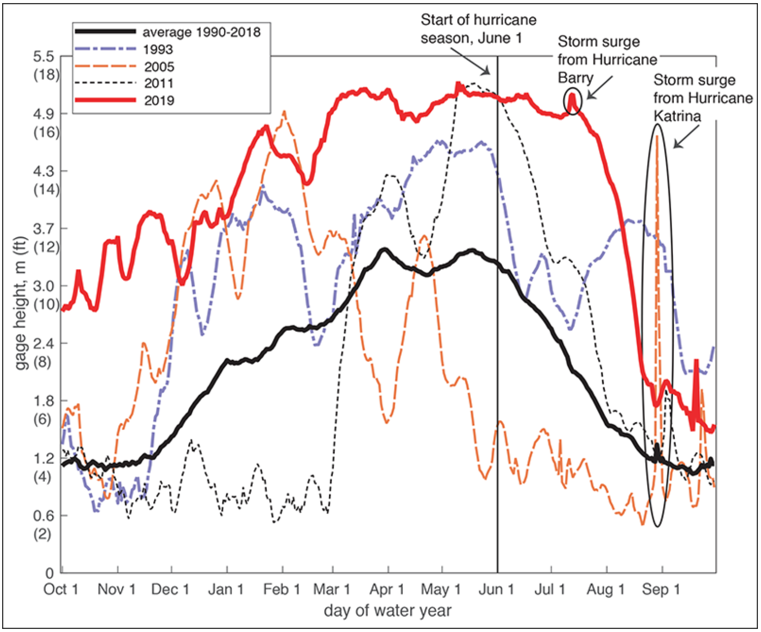
Figure 1: Comparison of the daily water levels at New Orleans (Louisiana) for past years (7). During 2019, the river level at New Orleans remained above flood stage for more than six months, hindering the navigation across this crucial section of the Mississippi River.
How to adapt at a regional level?
Traditionally, river engineering has trusted flood protection to levees, as is the case of the Mississippi Basin. However, they have been proven to be ineffective due to the fact that they restrict the river sections, causing higher river levels. An alternative to this approach is to combine soft and hard engineering solutions to manage high river levels, when applied at a regional scale. The relocation of levees, the creation of water buffers and the construction of flood bypasses are three key techniques which have been implemented in other countries with river conveyance capacity problems such as the Netherlands (8).
As an example of the cost-efficiency of nature-based solutions, research studies have proven that the restoration of wetlands on only 1.5% of a landscape can reduce flood peaks by up to 29%, in terms of maximum water volumes and levels (9). The benefit of such a regional approach is not only limited to communities located in the riverside, which would see their individual risk reduced, but also private owners (such as inland waterway freight transport companies) that are key contributors to the development of the regional economy.
How to adapt at a company-level?
The quantification of the transport risk associated to future extreme river levels is the key to adapt the company business contingency plans to any potential adverse scenario. While the combination of soft and hard engineering solutions are proposals to be applied at a regional scale and require several years for implementation, there are also alternative solutions applicable at a local scale that could be implemented in the short term. One of them is the risk transfer by means of parametric insurance, that provides financial coverage for property damage and business interruption. Parametric insurance can also cover expenses from the implementation of flood contingency plans, such as the deployment of temporary flood defences or the use of alternative transport modes to ensure business continuity (such as the transport by truck). Furthermore, the implementation of early warning services to anticipate the occurrence of extreme events can help to coordinate and execute the contingency plan actions to mitigate the impact effectively.